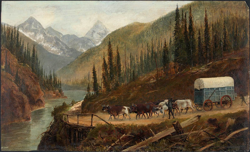
Well, in short they walked. Yes, you read that right. They walked across the United States right beside their wagons which were pulled by oxen, some by mule. Some of the pioneers rode horses and mules but most walked. There were several main trails to the west but most of them began in Independence, Missouri.
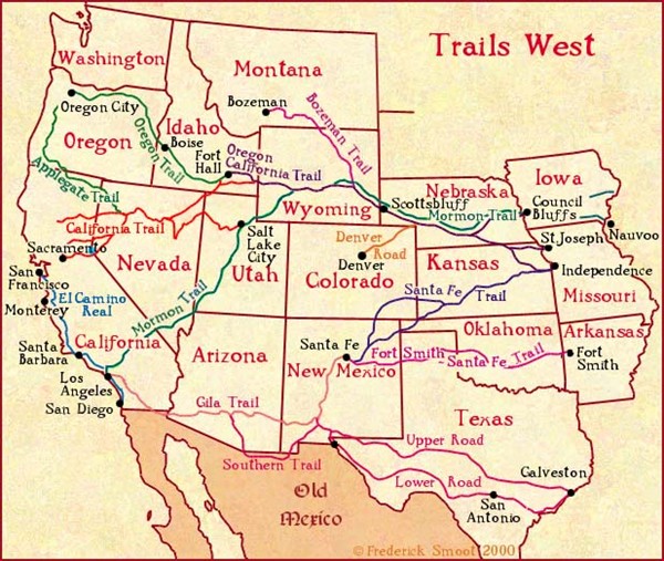
The Trails
Your starting point and destination determined which trail was taken. The pioneers were sure to encounter all types of terrains and climates along the way. It was necessary for them to be prepared. Poor preparation could lead to death. The trails were not like our roads that we have today. They ranged from thick woods to foot paths to walking across rivers to climbing mountains, while pulling wagons!
Here are the main trails:
https://www.tngenweb.org/tnletters/usa-west.htm
green=
dark blue and purple= Sante Fe Trail
red=California Trail
light blue=El Camino Trail
green and purple=Oregon Trail
California Trail Facts
- used b1841 to 1869
- there were several starting
points along Missouri River - the trail ran parallel to the Oregon Trail
- split from the Oregon Trail and headed south over the Sierra Nevada Mountains
- about 2,000 miles long
- difficult to follow
- people usually left mid April to early May (if they left sooner there would not have been enough grass for their animals to graze, if they left later they might get stuck in snow in the mountains)
- followed the Platte River for awhile
- 40 mile desert part of trail
- INTERACTIVE MAP CALIFORNIAA TRAIL: https://mrnussbaum.com/california-trail-interactive-map
Sante Fe Trail
- stretched for 900 miles
- terrain included: praries, deserts and mountains
- had 2 main routes (Mountain Fork went thru Colorado while the Cimarron Fork went thru Kansas)
- The Cimarron Fork was shorter but had limited water
- Indians were more of a problem on this trail
- Forts were built along trail
- INTERACTIVE MAP: https://mrnussbaum.com/the-sante-fe-trail-introduction-and-interactive-tour
Mormon Trail
- followed the northern
bank of the Platte River - went through Nebraska to Fort Laramie in Wyoming
- from Fort Laramie it went to the Salt Lake Valley
- stretched 1,300 miles
- travelers who used this trail used part of the Oregon and California Trails
- travelers used wagons and hand pushed carts
- INTERACTIVE MAP: https://mrnussbaum.com/along-the-mormon-trail-introduction
Oregon Trail
- 2,500 miles
- crossed 6 different states: Missouri, Kansas, Nebraska, Wyoming, Idaho and Oregon
- starting point Independence, Missouri
- ended in Oregon City, Oregon
- emmigrants fished and hunted along trail for food
- vegetables were available at forts and trading posts
- the trail had tight corners and special wagons were used
- Landmarks along trail: Courthouse, Jailhouse and Chimney rocks, Fort Larimie, Independence Rock, Fort Bridger, Doda Springs. Fort Hall, Fort Boise, Whitman Mission and the Dalles
- INTERACTIVE MAP: https://mrnussbaum.com/stop-1-along-the-oregon-trail-independence-missouri
El Camino Trail
- 404 miles
- decends into the Rio Grande Valley from San Juan Pueblo New Mexico to El Paso Texas
- connected footpaths to Mexican trade routes
- much older than the other trails
- was first used as a trade route between Mexico City and San Juan Pueblo
"In teaching others we teach ourselves" - Proverb
Have Fun!
The Team at Educator Pages